Author: kayriyadh

More about industry

Types of industry

Industry is any economic activity which creates jobs and generates income.

There are four main types of industry:

  • Primary sector
  • Secondary sector
  • Tertiary sector
  • Quaternary sector

Primary industry involves the production or extraction of raw materials and includes forestry, farming, fishing and mining.

Secondary industry is the manufacturing of goods. For example, the northwest of England used to have a thriving textile industry making cloth from cotton, China has a thriving manufacturing sector producing electronics, and Germany is one of the largest manufacturers of cars.

Tertiary industry involves providing services to people, for example a cleaner or a doctor.

Quaternary industry is the newest sector and focuses on knowledge-based industries or high-tech industries such as ICT (information and communication technologies) and research and development.

The Clark Fisher model shows how a country changes its focus.

The effects of industry

Different countries around the world are at different stages of industrial development and there are regional variations within countries. Countries rely on each other for the manufacture and sale of goods to take place. For example, raw materials may be bought in one country, used to manufacture goods in another, and then sold in a third country. This can have positive benefits as it improves co-operation between countries through international trade but can also be a source of conflict.

As countries develop, they move through the phases of the Clark Fisher model. When a country no longer mainly manufactures goods and moves into the service sector, this is known as de-industrialisation.

Economic effects

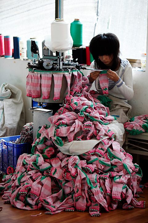
A woman sat on a bench with a large pile of socks in front of her whilst she makes them.
In some countries wages are lower, for example it is cheaper to pay this person to make socks in China, than it would be to pay someone in the UK.

The transition of phases (Clark Fisher model) can happen for a number of reasons but one of the most significant is the off shoring of manufacturing from a high-income country (HIC) to a low-income country (LIC) or a newly emerging economy (NEE). An example of this is the relocation of aero plane engine production from Barnoldswick in Lancashire, in the UK, to Singapore. This is done for a number of reasons:

  • To increase profits by exploiting the lower cost of labour by paying lower wages.
  • To take advantage of less rigorous rules for example fewer environmental or health and safety laws.

Social effects

A crowd of miners wearing overalls with hard hats and the lights on their hard hats turned on.
Spanish miners demonstrating against industry cuts in 2012.

When primary and secondary industries, and their workers, are abandoned in favour of new industries this can lead to conflict within a country.

This happened in the United Kingdom in the 1980s as the government decided to move from the secondary sector to a new phase of post-industrialism, where the tertiary and quaternary sectors were encouraged.

The decline in primary and secondary industries in many places has led to unemployment and many other social issues.

The countries who benefit from a decline elsewhere in primary and secondary industries are the newly emerging economies (NEEs). Nigeria, for example, as it moves into the industrial phase of their development and begins to develop tertiary industries, can use the money generated to improve schools, hospitals and infrastructure in the country and provide jobs for the workforce.

Environmental effects

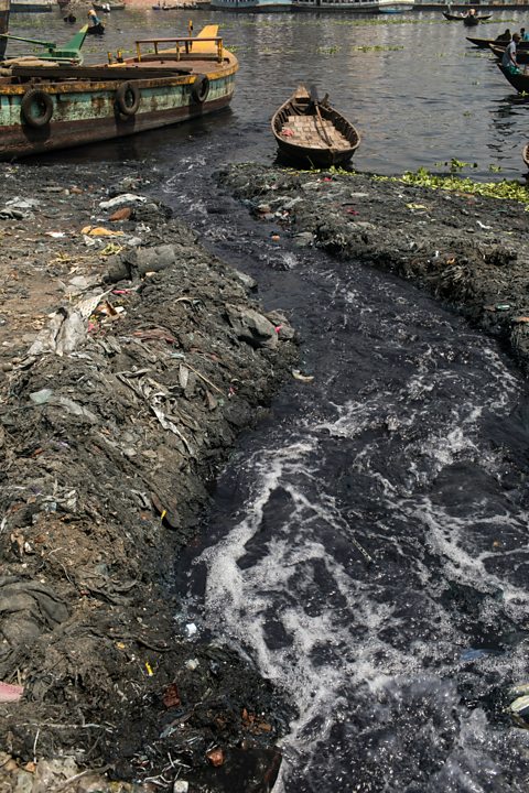
Water running down into a river.
Toxic water from tanneries running straight into the Buriganga River (Bangladesh), which turns black because of the pollutants. This river used to form part of the end of the Ganges.

There may also be negatives for these countries as industry can be polluting.

For example, leather manufacturing is one of the largest causes of pollution in the River Ganges in India. This includes waste water from factories being released into rivers and lakes along with chemicals.

Increasingly there are calls for a new ‘Green Industrial Revolution’ in manufacturing with a move away from polluting industries such as energy production using fossil fuels towards the development of green, environmentally friendly, technology such as wind turbines.

In 2020 the UK government announced a ten-point plan for a green industrial revolution to support green jobs and move towards a zero-carbon economy.

Political effects

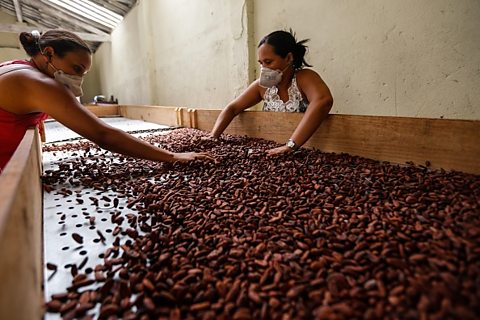
Two people sifting through a large pile of beans on a flat surface.
Workers sorting cocoa beans by quality, before they are exported to be made into chocolate in Bahia state (Brazil)

Low-income countries (LICs) tend to still rely on the export of raw materials, such as cocoa beans, to more developed countries to be converted into manufactured goods, such as chocolate. This can lead to exploitation of the poorer countries by those who are richer and reinforces the dominance of already powerful nations.

Question

When a country no longer focuses on manufacturing goods and moves into the service sector what is this process called?

When a country no longer focuses on manufacturing goods and moves into the service sector this is known as de-industrialisation.

Secondary industry

Examples of secondary manufacturing industries of different scales are:

(a) small-scale: engineering in the Punjab,

(b) medium-scale: Sterling Plywood Industry in Karachi, Processing Industries in Malaysia and Sri Lanka,

(c) large-scale: iron and steel in Pakistan and Japan

rali making – a household industry in Sindh

carpet weaving on small scale

small scale engineering in the Punjab

Define ‘tertiary industry’. [1]

………………………………………………………………………………………………………………………….
……………………………………………………………………………………………………………………. [1]

Name two examples of a tertiary occupation.
1 …………………………………………….
2 ……………………………………………. [2]

Define ‘formal’ and ‘informal’ sectors of industry. [2]

State two job types found in the formal sector and the informal sector of the tourism industry. [4]

Jobs in the informal sectorJobs in the formal sector
  
1           1
  
2           2

State two advantages and two disadvantages of the informal sector to the tourist industry in Pakistan. [4]

AdvantagesDisadvantages
  
1           
  
2           

Study the following figure, a divided bar graph showing the international tourism revenue for different world regions in 2017 as a percentage of the world total.

Using the figure only:
– which region had the highest percentage of the world total?
………………………………………………………..
– which region accounted for 3% of the world total?
………………………………………………………..
– what percentage of the world total was accounted for by the Asia‑Pacific region?
…………………………………..% [3]

Study the following figure, a photograph showing a tourist attraction in Pakistan.

Describe two attractions to tourists of the area shown.
1 ……………………………………………………………………………………………………………………….
………………………………………………………………………………………………………………………….
2 ……………………………………………………………………………………………………………………….
…………………………………………………………………………………………………………………………. [2]

Name and describe three cultural attractions of Pakistan.
1 ……………………………………………………………………………………………………………………….
………………………………………………………………………………………………………………………….
2 ……………………………………………………………………………………………………………………….
………………………………………………………………………………………………………………………….
3 ……………………………………………………………………………………………………………………….
…………………………………………………………………………………………………………………………. [3]

Study the figure, a photograph taken inside a steel mill in Pakistan.

Using the figure only, describe three features of the steel mill shown.
1 ……………………………………………………………………………………………………………………….
………………………………………………………………………………………………………………………….
2 ……………………………………………………………………………………………………………………….
………………………………………………………………………………………………………………………….
3 ……………………………………………………………………………………………………………………….
…………………………………………………………………………………………………………………………. [3]

Explain two factors influencing the location of the iron and steel industry in Pakistan. You
should develop your answer.
1 ………………………………………………………………………………………………………………………………
…………………………………………………………………………………………………………………………………
…………………………………………………………………………………………………………………………………
…………………………………………………………………………………………………………………………………
2 ………………………………………………………………………………………………………………………………
…………………………………………………………………………………………………………………………………
…………………………………………………………………………………………………………………………………
………………………………………………………………………………………………………………………………… [4]

Study the following figure, a photograph of an area near Karachi used by tourists.

Using the figure only, state two natural attractions of the area shown.
1 …………………………………………….
2 ……………………………………………. [2]

Suggest how tourists may use the area shown in the above figure.
………………………………………………………………………………………………………………………….
………………………………………………………………………………………………………………………….
………………………………………………………………………………………………………………………….
………………………………………………………………………………………………………………………….
………………………………………………………………………………………………………………………….
……………………………………………………………………………………………………………………. [3]

Describe two features of large-scale industry.
1 ……………………………………………………………………………………………………………………….
………………………………………………………………………………………………………………………….
2 ……………………………………………………………………………………………………………………….
…………………………………………………………………………………………………………………………. [2]

Study the following figure, a diagram showing oil prospecting and drilling.

Complete the labels on Fig. 3.1 by choosing the correct words from the list below.
derrick drill pipe refinery valves [2]

Complete the following figure, which is a divided bar graph, using the information below to show the
employment structure of Pakistan:

Complete the table by classifying the jobs from the list below into the correct categories.
An example has been done for you.

Define the term ‘secondary industry’.
………………………………………………………………………………………………………………………….
………………………………………………………………………………………………………………………[1]

State a feature of each of the following types of industry:
cottage industries; ……………………………………………………………………………………………….
………………………………………………………………………………………………………………………….
small-scale industries; ………………………………………………………………………………………….
………………………………………………………………………………………………………………………….
large-scale industries. ………………………………………………………………………………………….
………………………………………………………………………………………………………………………[3]

O level / IGCSE Geography past paper practice | Natural resources – an issue of sustainability ((a) Water)

summer 2023

1 (a) (i) Study Fig. 1.1, a map showing southern Pakistan and surrounding countries.

On Fig. 1.1 label the following: Afghanistan, India, Iran. You should write the name in the
correct location on the map. [3]

(ii) Add a dot and the letter K onto Fig. 1.1 to show the location of Karachi. [1]

(iii) Using Fig. 1.1 only, what is the approximate length of Pakistan’s coastline? Circle the
correct answer.
500 km 1000 km 1500 km [1]

1000 km
1 @ 1 mark

(iv) Name the rivers labelled X and Y on Fig. 1.1.

X: River Hub (Hab)
Y: River Ravi
2 @ 1 mark

(b) Suggest four ways in which rivers are important to Pakistan.

 source of water/create reservoirs (domestic use/people to drink)
 to provide a source of food/fish (to eat)
 for transport (people/goods)
 to provide nutrients/alluvium to the soil/flood plain/mangroves
 for farming/agriculture/irrigation (of fields/crops)
 for livestock/cattle/buffalo to drink/bathe/cool down
 fish farming/commercial fishing/aquaculture
 named manufacturing industry e.g. cement/textiles
 for cooling in power stations/industry
 habitat for wildlife/biodiversity/ecosystems
 afforestation projects
 to produce hydel/hydroelectric power/electricity
 to add to scenic beauty to the area (for tourism)
 for leisure activities/named example e.g.
boating/swimming/photography/fishing
 for employment in a named industry e.g. fisherman/farmer
4 @ 1 mark

(d) Water is a valuable resource for the continued sustainable development of Pakistan. Read
the following two views about providing water:

Which view do you agree with more? Give reasons to support your answer and refer to
examples you have studied. You should consider view A and view B in your answer.

Content Guide

Agree with view A because:

 untreated sewage/industrial effluent makes water unusable
 dumping of waste in rivers is not strictly regulated
 regular flooding causes fresh water supply to be contaminated
 removing pollution from water is expensive and reduces the money available for water provision infrastructure
 etc.

Disagree with view A because:

 water pollution can be easily solved/prevented by imposing laws and fines on industries/companies who pollute the water
 there are more serious threats to Pakistan’s water supply such as climate change e.g. increased risk of drought/flooding
 a bigger threat is from neighbouring countries limiting the water supply from the headwaters
 etc.

Agree with view B because:

 rising temperatures increase evaporation from reservoirs so more of them are needed
 global warming is melting glaciers in the mountains, more dams are needed to store water in reservoirs
 Pakistan needs more water storage capacity to hold heavy rainfall e.g. in monsoon season, so water can be utilised
 more reservoirs could alleviate future drought conditions if available supply was stored
 more small dams across the country could aid in crop irrigation
 it would be very expensive to build more dams/money is needed for other sectors.
 etc.

Disagree with view B because:

 there are enough dams already, those under construction need to be completed
 existing dams are not all in the places where need is greatest therefore they have limited use
 silting of reservoirs causes lower capacity making them less worthwhile
 water conservation is a better solution than building more dams
 conflicts over how water is used is a bigger threat
 etc.

Examples: could include named dam/pollutant/settlement/river etc. but not named diseases.

winter 2023

(b) (i) Barrages have been built on many rivers. Name two barrages in Pakistan.

Balloki / Chashma / Ghazi Brotha / Guddu / Islam / Jinnah / Kotri / Khanki / Marala / Mohammadwala / Panjnad / Qadirabad / Rasul / Sinhnai / Sulemanki / Sukkur / Trimmu / Taunsa
2 @ 1 mark

(ii) Suggest how barrages can be useful to farmers.

  • can be built on low/flat land/plains/near to farming areas
  • regulate/control the flow of water in a river/keep river levels stable
  • provide a reliable/constant supply of water
  • help to prevent/control flooding
  • gates are opened to let water into the river
  • gates are closed to hold water back
  • help with irrigation/in watering crops/direct water for irrigation/water can be diverted to perennial canals/provide water for livestock
    3 @ 1 mark

winter 2022

(c) (i) Study Fig. 2.2, a pie chart showing the percentage share of Pakistan’s total irrigated
area by method of irrigation.

Complete Fig. 2.2 to show the percentages of Pakistan’s total irrigated area which are
irrigated by tubewells and by wells and other. Use the information below and the key.

Complete Fig. 2.2 to show the percentages of Pakistan’s total irrigated area which are irrigated by tubewells and by wells and other. Use the information below and the key.
Point accurately plotted and line drawn
Shading completed accurately using the key
Note: sections can be plotted in either order. 1 mark for line drawn at 80% or at 97%/1 mark for shading both sections accurately.
2 @ 1 mark

(ii) Explain two ways in which a karez irrigation system is operated to grow dates and
vegetables in a desert oasis. You should develop your answer.

  • it is usually owned by a group of people in the village (rather than an individual); they share responsibility for its operation/share the water/share the costs of building/maintenance
  • a (mother) well is dug down to the watertable/ground water; to access water underground/(using gravity) a tunnel brings water to the surface
  • the tunnel is dug/starts from the base of a hill or mountain; this allows water to be transported from underground to dry areas where it is needed
  • a tunnel/narrow underground canal; minimises evaporation (in the hot desert climate)
  • the tunnel can run for a long distance/<10 kms/emerges at ground level; water is then taken to/used to irrigate/water the crops/fields (of dates and vegetables)
  • where the tunnel reaches the surface/emerges trees are planted; this provides shade/reduces evaporation
  • the karez is dotted with vertical shafts; this allows for cleaning/repairs to prevent blockages in the tunnels (and if completed regularly the karez can last for a century or longer)
    Note: 1 mark for simple point and a further mark for the development of the point. 1 mark for second simple point and a further mark for development of the second point.
    Note: Max. 2 marks if no development.
    2 @ 2 marks

(iii) Suggest two disadvantages of using the karez system of irrigation.

  • (traditional skilled) labour is needed to dig/maintain the tunnels/not many people with this knowledge/skill
  • digging/boring/maintenance takes a lot of workers/time/is hard manual work/is dangerous work/requires machinery
  • is expensive to build/lining the tunnels with (pvc/plastic) pipes is expensive
  • machinery used to bore/dig causes air pollution/harmful gases
  • owned by a co-operative/many owners/different percentage shares/can cause conflict/disagreements over sharing/not enough to go around
  • water flowing through a karez cannot be stopped/water can be wasted/it is inefficient/tunnels can leak/water is absorbed into the ground/supplies too much water/can spoil crops
  • have to use the water as soon as it flows (any time of day)
  • need frequent maintenance/repairs/cleaning
  • water is drying up/use of tubewells has lowered the water table/wells and tunnels must be dug deeper
  • water is not (always) taken directly to the crops/(often) has to be transported to the crops/only irrigates a small area
  • only feasible in specific geological landscapes
    2 @ 1 mark

(d) To what extent can agricultural practices and water management be improved to prevent
waterlogging and salinity? Give reasons to support your judgement and refer to examples
you have studied. You should consider different points of view in your answer.

Content guide
It is possible to improve agricultural practices and water management to prevent waterlogging and salinity by:

  • leaving parts of the land fallow – preventative measure
  • building more dams/reservoirs to store more water
  • lining/temporary closure of canals to reduce water leakages
  • installing tubewells to flush the salt out of the soil/so flow of water for irrigation can be controlled
  • planting eucalyptus trees to take in excess water when land is badly waterlogged
  • digging surface/sub-surface drains
  • removing salts by adding gypsum/by reducing fertiliser use
  • Salinity Control and Reclamation Projects (SCARP)
  • government legislation, e.g. water quotas
  • cultivating salt tolerant crops
  • using high-yielding varieties which require less irrigation
  • using saline land for livestock farming

It is not possible to improve agricultural practices and water management to prevent waterlogging and salinity due to:

  • cost/time taken for farmers to maintain canals/tunnels
  • lack of investment in methods
  • replacing traditional methods with tubewells lowers the water table and provides water for fewer farmers
  • literacy/education levels may mean some farmers continue to over-irrigate
  • SCARP projects date from 1958 and large public tubewells are deteriorating/reaching end of their life
  • lack of access to/cannot afford high yielding varieties
  • traditional irrigation systems are communally owned, change requires agreement/may generate disagreement

summer 2021

2 (a) (i) Study Fig. 2.1 showing a blank divided bar graph.

Complete Fig. 2.1 to show the percentage share of each source of surface water in
Pakistan. Use the information in the key. [5]

  • each correct division showing percentage share of each source of surface
    water = 1 mark – max 2 marks;
  • each correct labelling or shading of each source of surface water = 1 mark
    – max 3 marks.
    Note: Any order accepted.
    5 @ 1 mark

(ii) State three ways water is obtained for domestic purposes in Pakistan.

  • directly from rivers/glaciers/lakes/pond;
  • from wells/groundwater/from aquifers;
  • via pipelines/water tankers/from reservoirs/taps;
  • collecting rainwater (in tanks on the roof);
  • using desalination.
    3 @ 1 mark

(b) (i) Explain how water is used in two different secondary industries in Pakistan. You should
develop your answer.

  • thermal power stations; to produce steam to move the turbines;
  • mineral water industry; for bottling water this is the only input;
  • iron and steel industry; to cool the furnace;
  • HEP stations; pressure of water from a height or steep slope to move the
    turbines;
  • pharmaceutical industry; in the manufacture of drips, syrups, injections
    etc;
  • tanning industry; for washing/dyeing etc;
  • food processing/beverages; for preparing
    juices/squashes/syrups/beverages etc;
  • chemical industry; for manufacturing acids/bleach/other solutions etc;
  • textile industry; for washing/bleaching/ blueing/dyeing/printing etc;
  • cement industry;
    Etc.
    Note: One mark for identification of appropriate idea and a further mark for
    development.
    Note: Max. 2 marks if no development.
    2 @ 2 marks

(ii) Define ‘irrigation’.

It is the artificial supply of water to the land.
1 @ 1 mark

(iii) Name and describe one type of conventional irrigation system used in Pakistan.

  • shaduf; water is drawn from a well, river or canal by a bucket.
  • charsa; animal power is used to pull water from the well.
  • Persian wheel; powered by a bullock which turns a wheel with a series of
    pots attached to raise the water from well and tip it into the channels that
    lead to the field.
  • karez; horizontal underground canal in the foothills and brings the
    underground water to the surface where it can be used.
  • inundation canals; long canals taken off rivers. They fill when the river is
    high enough and when it is in flood.
  • diversion canal; a narrow version of an inundation canal and are often
    used in steep areas so that they can take water to small terraced fields.
  • tank irrigation; mud banks are constructed across small streams to make
    a small reservoir to collect water in the rainy season.
    Note: One mark for named technique and one mark for description.
    2 @ 1 mark

(c) Outline two advantages and two disadvantages of using irrigation on small-scale subsistence
farms.

Advantages:

  • can produce higher yields;
  • extends farming seasons/can cultivate all year round;
  • more land used for cultivation/can cultivate marginal land;
  • can control the amount of water used;
  • can grow a wider range of crops;
  • can use over a wide area;
  • saves time;
  • more reliable than rainfall;
  • can be cheap to install e.g. Persian wheel;
    Etc.
    Disadvantages:
  • cost of installation/maintenance;
  • difficult to build;
  • inundation canals only flow during rainy periods or when glacial/snow
    melt enters the rivers;
  • waterlogging of soil;
  • can increase salinity of soil;
  • can cause siltation of barrages;
  • unlined canals lead to seepage;
    Etc.
    Note: advantages = max 2 marks, disadvantages = max 2 marks
    4 @ 1 mark

(d) The United Nations has predicted that Pakistan may become a ‘water scarce’ country by 2025.
To what extent can effective management of its water supply help Pakistan to avoid becoming
a ‘water scarce’ country in the future? Give reasons to support your judgement and refer to
examples you have studied. You should consider different points of view in your answer.

Content Guide
Answers are likely to refer to:
Effective management of the water supply may help because:

  • Pakistan has enough water but it is not evenly spread throughout the
    country;
  • much water is lost through existing irrigation systems using traditional
    methods;
  • water is polluted through industrial and domestic waste/limited
    environmental regulation;
  • Pakistan needs to educate the people further about conserving
    water/reusing grey water;
    Etc.
    Effective management of the water supply may not help because:
  • population growth is leading to water scarcity and this should be tackled
    first;
  • Pakistan is suffering the consequences of climate change and this is an
    international issue that requires multi-national agreements;
  • the Indus Water Treaty causes many issues and needs to be updated;
    Etc.

winter 2020

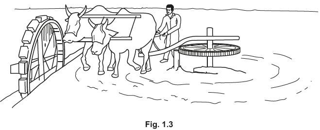
(ii) Study Fig. 1.3, a diagram showing a type of lift irrigation.

Describe how water is obtained for irrigation using this method.

  • Persian wheel;
  • animals are used to turn/moves a wheel;
  • the animals are blindfolded;
  • turns a horizontal/smaller wheel;
  • attached/geared to a vertical/larger wheel;
  • buckets or pots attached to the wheel;
  • the pots raise water from the well;
  • pots spill contents into the channel to fields/irrigate field.
    4 @ 1 mark

(iii) List two ways the livestock shown in Fig. 1.2 can be used other than as draught power
for irrigation.

  • ploughing/threshing/harvesting;
  • pulling carts;
  • carrying heavy loads/raw materials/people/transport;
  • for meat/milk/skin/hides/dung/or other product.
    2 @ 1 mark

(iii) What is waterlogging? Tick (3) one correct answer from the list below:

The water table rises to the surface.
1 @ 1 mark

winter 2019

2 (a) Study Fig. 2.1, a map showing the major rivers of Pakistan.

(i) Name rivers V, W, X and Y.

V = Indus
W= Jhelum
X = Chenab
Y = Ravi
4 @ 1 mark

(ii) Name dam Z shown on Fig. 2.1.

Z= Mangla Dam
1 @ 1 mark

(b) (i) Name two examples of barrages.

  • Amandarra
  • Balochi
  • Chasma
  • Guddu
  • Islam
  • Jinnah
  • Kotri
  • Kurrangarhi
  • Marala
  • Panjnad
  • Qadirabad
  • Rasul
  • Siddha
  • Sukkur
  • Sulaimanka
  • Taunsa
  • Trimma
    2 @ 1 mark

(ii) State the differences between barrages and dams.

  • Dams store water / barrages control flow of water;
  • Barrages can supply little / small amounts / no electricity (dams are
    major suppliers of hydel power);
  • Silting is a problem for dams (but not barrages);
  • Maintenance cost is lower for barrages (more expensive for dams);
  • Construction and or maintenance time is quicker for barrages (longer
    for dams);
  • Construction cost is lower for barrages (more expensive for dams);
  • Fewer or no people have to be evacuated for barrages;
  • Barrages have less environmental impact than dams;
  • Barrages can be built on flat land (dams require steep slopes);
  • Dams have multiple uses whereas barrages do not;
  • Dams provide water for a larger area than barrages;
  • Barrage to deviate channel to an area where there is no river;
  • Do not need to excavate a large area for barrages.
    4 @ 1 mark

(iii) Suggest four problems caused by siltation. [4]

  • Reducing water supply / less water available / water becomes silty /
    pipes blocked / reduces capacity of reservoir / less water stored;
  • Blocking the flow of water / blocks canals or rivers / chokes or blocks
    irrigation canals or pipes / water cannot get through / floods may occur;
  • Weakens foundations of dams / have to be emptied or strengthened /
    flow of flood water is hampered and can damage dam / damage to
    turbines or machinery;
  • Not enough water for irrigation / industry / domestic use;
  • Reduces water available for hydel power / generation of hydel power
    stopped;
  • Encourages growth of algae / eutrophication.

(c) Explain why rivers are important to Pakistan. You should develop your answer.

  • Scenic beauty; for tourism / picnic / leisure (dev);
  • Provides water; especially to areas where rainfall is low/named;
    examples / sustains life or drinking water (dev);
  • Helps to generate hydel power / electricity; which reduces power
    shortages / reduces need to import coal or oil / reduces need to use
    fossil fuels (dev) / one of main sources of electricity;
  • Adds alluvium to soil; so, improves the fertility of the soil / aids crop
    growth (dev);
  • For fishing industry / subsistence fishing; provides income or food
    supply to local areas / people (dev);
  • Provides water for domestic use / in the home; named examples, e.g.
    cooking / cleaning (dev);
  • Provides water for industries; named examples, e.g. cement, brick
    making, cotton (dev);
  • Provides water for irrigation / agriculture / farming; used to irrigate /
    water crops / feed livestock / or named examples, e.g. wheat / cotton /
    sugar cane (dev);
  • Transport; for trade / avoid using roads or rail / access to ports (dev);
    Etc.
    Note: One mark for identification of appropriate idea and a further mark for
    development (in parentheses).
    Note: Max. 2 marks if no development.
    2 @ 2 marks

(d) Read the following two views about providing solutions to the challenges of water supply in
Pakistan:

Which view do you agree with more? Give reasons to support your answer and refer to
examples you have studied. You should consider View A and View B in your answer.

Content Guide
Answers are likely to refer to:
Small dams

  • Cheaper to construct;
  • Less technical expertise needed;
  • Can be built more quickly;
  • Minimal disruption to people and environment;
    Etc.
    Large dams
  • More people will benefit;
  • Can produce HEP which is good for developing the country;
  • Provides employment opportunities;
  • A bigger area is utilized;
    Etc.

summer 2017

4 (a) (i) Study Fig. 5, which shows a diagram of the karez system of irrigation.

Choose three terms from the list below and use them to label the diagram in three of the
spaces provided.
maintenance shaft aquifer canal tunnel water table [3]

Any three of (L to R):
canal, aquifer, water table, maintenance shaft, tunnel
3 @ 1 mark

(ii) Give an example of a barrage in Pakistan and name the river it is on.

(iii) State why barrages are needed in Pakistan.

  • Irrigation/release water for irrigation;
  • Provide water supply to perennial canals/link canals;
  • Flood control;
  • Flow of water controlled;
  • To stimulate economic development/industry/settlement.
    2 @ 1 mark

(b) (i) Describe two ways in which the atmosphere in Pakistan can be polluted.

  • Smoke/fumes/gases/named gases/harmful gases from
    factories/tanneries/industries/chimneys/power stations;
  • Smoke/fumes/gases/named gases from vehicle exhausts;
  • Burning fossil fuels;
  • Clearing forests by burning;
  • Release of gases/methane from livestock/rice/paddy fields/landfill;
  • Burning domestic rubbish/incineration;
  • Air pollution/dust from mineral extraction/mining/ quarrying.
    2 @ 1 mark

(ii) Explain how the use of chemical fertilisers on farms damages the natural environment.
You should develop your answer.

  • Cause pollution of rivers/watercourses (runoff from farmland
    containing chemicals washes into them);
  • Pollution of groundwater (from infiltration eventually entering rivers,
    polluting them);
  • Eutrophication in rivers (nitrates/phosphates cause algal blooms
    which increase CO2/reduce O2)/(killing fish/aquatic animals/destroy
    aquatic life);
  • Causes ecosystem to be unbalanced (through loss/ extinction of
    species) (through disruption to food chains/ food webs);
  • Overuse of fertilisers (damages soil/makes soil infertile/
    poisons/damages natural vegetation).
    ETC.
    Note: One mark for identification of appropriate idea and a further mark for
    development (in parentheses).
    Note: Max 2 marks if no development.
    2 @ 2 marks

(c) Study Fig. 6, which shows water use by sector in Pakistan in 2008.

(i) A Which sector used least water?

B How much water was used by the irrigation/livestock sector?

A Domestic
B 94% (allow 93–95%)
2 @ 1 mark

(ii) Name a type of industry that uses large amounts of water.

One of:
Beverages/soft drinks/juice industry/dyeing/tanning/printing/
iron/steel/nuclear/textiles/chemical/pharmaceutical/hydel/
HEP/paper/tourism/leisure/inland fish farms.
1 @ 1 mark

(iii) About 60% of irrigation water is lost before it reaches crops. Give three reasons why
irrigation water is lost in this way.

  • Seepage from beds of canals/absorbed into the soil/land/no canal
    lining;
  • Evaporation/evapotranspiration from surface of
    canals/tanks/flooded land;
  • Excessive runoff of water immediately into streams/rivers;
  • Theft of water/theft from canals;
  • Water drawn up by vegetation on side of canal;
  • Mismanagement.
    3 @ 1 mark

(d) Read the following two views about water shortages in Pakistan:

Which view do you agree with more? Give reasons to support your answer and refer to
examples you have studied. You should consider both View A and View B in your answer.

Content Guide:
Answers are likely to refer to:
For infrastructure

  • Prevents loss of water downstream into sea
  • Collects rainfall/snowmelt
  • Reservoirs feed perennial canals
  • Can store large amounts of water
    Against infrastructure
  • Source of conflict between countries and provinces
  • Social issues
  • Loss of fresh water at Indus Delta
  • Water intrusion into Sindh
  • High initial investment
  • Little use in Balochistan where rivers dry up
  • Mismanagement by provincial/national government
  • Siltation occurs
    For water saving
  • Planting trees
  • Lining canals
  • Careful monitoring/regulation of amount of water used
  • Better forms of water storage in homes
  • Water meters in homes/industries
    Against water saving
  • Long time scale required to educate sufficient number of people
  • Resistance to education
  • Water a valuable raw material in industry
  • Growing population with increasing demand for drinking water
  • Development goal to increase availability of water
    ETC.

summer 2016

4 (a) (i) Study Fig. 7 which is a diagram of an HEP (Hydel) power station.

A. On the diagram place an arrow or arrows to indicate the direction of movement of
water through the power station.
B. Choose two terms from the list below and use them to label the diagram in two of
the spaces provided.
outflow turbine reservoir dam [3]

A: Arrow(s) drawn downwards through channel
B: From L to R: reservoir dam turbine outflow
NB: ‘water intake’ top left space not used

(ii) Name one multi-purpose dam in Pakistan. [1]

Tarbela/Mangla/Warsak

(iii) Give two uses for a dam such as the one you named in (ii). [2]

HEP/electricity [generation]
Irrigation
Water supply / stores water [for industrial/domestic use]
Controlling floods
Recreation/named recreational use/tourist attraction
Fishing
O level / IGCSE Geography past paper practice | Natural resources – an issue of sustainability ((b) Forests)

winter 2023

3 (a) (i) Study Fig. 3.1 (Insert), a map showing natural vegetation types found in southern
Pakistan.
Using Fig. 3.1 only, describe the distribution of riverain forest / bela.

  • (only) along the River (Indus)/both sides of the river
  • southern part of River (Indus)
  • S/SE/E of Pakistan
  • linear pattern/in a line/in separate blocks/not a continuous line
  • there are 7 sections of forest
  • N/NE of Arabian Sea/W of India/E/SE of Iran/SE of Afghanistan
  • surrounded by tropical thorn/accurate direction from another named vegetation type
  • runs between latitude 24 °N to 28 °N
  • along longitude 68 °E (accept 67 °E to 69 °E)
  • begins (40–60km) inland/doesn’t reach the coast
  • 350–500km length (along the river)
    3 @ 1 mark

(ii) Study Fig. 3.2 (Insert), a photograph showing a type of vegetation found in Pakistan.
Identify the type of vegetation shown in the photograph. Circle the correct answer.
evergreen forest mangrove tropical thorn / rakh [1]

mangrove
1 @ 1 mark

(iii) Using Fig. 3.2 (Insert) only, describe two characteristics of the type of vegetation shown.

  • grow in water
  • roots are long/woody/thick/tangled/gnarled/knobbly ‘knees’
  • roots are above ground/above water surface/exposed
  • roots spread over a wide area/widespread/spread out
  • leaves are small/green/thick
  • leaves are pointing upwards/at the top
  • trunk(s)/branches are thin/multiple
    2 @ 1 mark

winter 2020

4 Study Fig. 4.1, a pie graph showing the percentage share of Pakistan’s total forest cover by
province-level area.

(a) (i) Complete the pie graph in Fig. 4.1 to show the percentage of total forest cover found in
Gilgit-Baltistan and Sindh. Use the information below and the key provided:

1 mark for accurate completion of line on pie chart (11%/9% or vice versa),
1 mark for Sindh correctly shaded, 1 mark for Gilgit-Baltistan
correctly shaded
3 @ 1mark

(ii) Complete the passage below about reasons for the variations in the percentage share
of forest cover shown in Fig. 4.1. Choose the correct words from the list and place them
in the spaces provided.

KPK has the largest percentage share of forest cover in Pakistan because the climate is more suitable for growing trees. There are fewer trees in Punjab because the land is needed for cultivation. Some areas may have suffered more from deforestation than others.
3 @ 1 mark

(b) (i) State three functions of forests in Pakistan.

  • provides shade/lowers temperature;
  • provides humus/fertilises soil;
  • prevent soil erosion/landslides;
  • reduces flooding/prevent silt/reduce surface runoff;
  • used for timber;
  • used for fuel wood/firewood/wood;
  • for making products e.g. furniture/boats/paper/trucks/bridges;
  • provide oxygen/reduce carbon dioxide/air pollution/purify air;
  • shelter for wildlife/habitat;
  • building houses;
  • for domestic use/cooking;
  • scenic beauty/recreation opportunities/tourism;
  • for medicinal purposes/in pharmaceutical industry;
  • provide moisture through evapotranspiration;
  • mangroves protect coastlines/provide breeding ground for fish;
  • provides food/fruit/nuts/herbs.
    3 @ 1 mark

(ii) State one difference between productive forests and protection forests.

  • productive forests are mainly natural/high tree density/forest canopy is
    closed/great commercial value/mostly used for extraction of
    timber/wood/firewood;
  • protection forests are mainly planted by people/man-made/often
    linear/along roads/railways/in parks/little commercial value/main
    function is to protect the soil/provide shade.
    2 @ 1 mark

(iii) Study Fig. 4.2, a diagram showing how altitude affects vegetation type.

Using Fig. 4.2 and your own knowledge, suggest how altitude affects the type and
amount of vegetation in Pakistan.

  • fewer trees grow as altitude increases/more trees grow at lower
    altitudes;
  • more variety of trees/forests/grow at lower altitudes/named
    examples/altitude affects temperature lower altitudes are warmer which
    results in a wider variety of trees/forests;
  • mangrove forests are along coastline/mouth of rivers/low altitude/sea
    level to 1000 m/irrigated/riverain/sub-tropical/tropical thorn;
  • high/mid-altitudes only have evergreen/coniferous/alpine trees/types of
    leaves described/sloping branches;
  • only coniferous grow 1000–4000 m;
  • altitude affects temperature/temperature decreases with height which
    results in stunted growth of trees at 4000 m and above/alpine forests;
  • 4000–4500 m only alpine grow/highest forest is alpine/alpine found just
    below snow line;
  • no trees grow above the snowline/above 4500 m.
    4 @ 1 mark

(c) Explain two effects of deforestation on the natural environment of Pakistan. You should
develop your answer.

  • exposure of soil (1); leads to soil erosion by wind or water (dev);
  • no roots to slow down infiltration (1); leads to flooding (dev);
  • habitat loss/less shade for animals (1); leads to extinction of
    animals/species (dev);
  • breaks down the food chain (1) leads to extinction (dev);
  • more CO2 in the atmosphere/more pollution in the air (1); increased
    global warming/climate change/increased temperatures/because trees
    act as filters/trees absorb pollutants (dev);
  • increased surface runoff (1); due to lack of roots to slow down
    movement of water/which could lead to flooding (dev);
  • amount of rainfall is decreased/water cycle disrupted (1); due to less
    evapotranspiration (dev).
    Note: One mark for identification of appropriate idea and a further mark for
    development.
    Note: Possible opportunity to allow a further mark or marks for additional
    development.
    Note: Max. 2 marks if no development.
    2 @ 2marks

(d) The United Nations environment programme supports Pakistan’s initiatives with forest
owners, the timber industry and forest-dependent communities to keep its forests alive and
healthy by controlling deforestation and degradation.
To what extent can initiatives on forests encourage further sustainable development in
Pakistan? Give reasons to support your judgement and refer to examples you have studied.
You should consider different points of view in your answer.

Content Guide
Answers are likely to refer to:
Forest initiatives can encourage further sustainable development

  • there is a financial incentive for the government/country to protect their
    forests and reduce deforestation;
  • it is an international initiative so likely to be implemented and monitored
    effectively;
  • specific criteria clearly identified for governments/countries to adopt;
  • examples of sustainable management strategies for implementation
    e.g. plant a tree for everyone cut down;
  • use of LPG/CNG or other fuels will lead to less deforestation;
  • education about the importance of trees and sustainable development
    of forests;
  • local landowners given a financial incentive to plant trees rather than
    other uses/named examples;
  • encourage eco-tourism;
    Etc.

Ideas against

  • individual landowners will still deforest areas if they need the land for
    other purposes or examples of what land is needed for;
  • it is not clear how much will be paid to the government/country for their
    co-operation;
  • the financial incentives may not be lucrative enough compared to the
    financial benefits of deforestation;
  • long term project/investment as takes time for trees to grow;
  • resistance to education about the importance of trees in some tribal
    areas;
  • political/government changes can alter forest laws;
  • initiatives may be mismanaged;
  • illegal cutting of trees/cutting cannot be controlled;
    Etc.
    Named examples could include: The Tarbela/Mangla Watershed
    Management Project/Rachna Doab Afforestation Project/Billion Trees
    project/Agha Khan Rural Support Programme etc.

summer 2018

2 (a) (i) Study Fig. 2.1, a map showing forest types in Pakistan.

Name the forest types shown at A, B and C:

  • Forest type A – Coniferous;
  • Forest type B – Subtropical scrub / subtropical dry / subtropical thorn / dry
    thorn scrub;
  • Forest type C – Tropical thorn / rakh.
    3 @ 1 mark

(ii) Using Fig. 2.1, name two areas in Pakistan where mangroves grow.

  • Coastal areas of Sindh / Indus Delta;
  • Coastal areas of Balochistan / Sonmiani Bay;
  • Along the coastline of / near the Arabian Sea.
    2 @ 1 mark

(b) (i) Describe two natural characteristics of mangrove forests.

  • Broad / big leaves / leaves have drip tips;
  • Leaves are leathery / have reduced number of stomata;
  • Low trees and shrubs;
  • Height 3–8 m;
  • Can survive in salty water;
  • Roots filter salt / have aerial roots / have prop roots / roots stick up out of
    water;
  • Prefer clean / unpolluted water.
    2 @ 1 mark

(ii) Describe two functions of forests.

  • Protect soil from erosion / being blown away;
  • Lower the temperature / provide shade / create a more pleasant
    environment;
  • Provide humus to fertilise the soil;
  • Provide raw materials / named example, e.g. timber (for industry) /
    furniture / medicines / firewood;
  • Many jobs depend on forests / examples of jobs;
  • Recreational value / promote tourism / provide scenic beauty;
  • Prevent floods;
  • Take in CO2 / release O2;
  • Provide habitat for wildlife;
  • Increase / encourage rainfall / create transpiration;
  • Help with desalination (Eucalyptus trees).
    2 @ 1 mark

(iii) Suggest three physical factors which determine the type and density of forests.

  • Altitude, e.g. high altitude = fir / spruce / alpine;
  • Precipitation, e.g. dry areas = thorny bushes / scrub;
  • Precipitation, e.g. high precipitation = coniferous / evergreen forests;
  • Soil type / edaphic factors, e.g. salty areas = mangroves / fertile soil =
    high density;
  • Temperature, e.g. low / cold = alpine;
  • Temperature, e.g. high / hot / warm = tropical scrub;
  • Presence of rivers = riverain / bela;
  • Presence of oases = individual trees / palms.
    3 @ 1 mark

(c) (i) Study Fig. 2.2, which shows a coniferous tree.

Explain how this type of tree has adapted to the climatic conditions it grows in. You
should develop your answer.

Ideas showing how the tree has adapted to the climate such as:

  • Evergreen – no need to renew leaves / short growing season;
  • Compact conical shape – stabilises the tree in windy conditions / releases
    snow / prevents snow accumulation;
  • Needles instead of leaves – reduces moisture loss;
  • Tall / straight trunk – in order to grow straight towards sunlight;
  • Cones – protect seeds during cold months;
  • Downward pointing branches – allows snow to easily fall off;
  • Shallow root system – as soils are thin / subsoil is frozen for most of the
    year;
  • Long / wide spreading roots – helps to anchor the tree against strong
    winds;
  • Thick bark – protects from cold winds.
    Etc.
    Note: One mark for identification of appropriate idea and a further mark for
    development (in parentheses).
    Note: Max. 2 marks if no development.
    2 @ 2 marks

(ii) State three causes of deforestation in Pakistan.

  • For farming / agriculture / growing crops / irrigation;
  • Urbanisation / growth of settlements;
  • Construction of roads / railways;
  • Industrialisation / growth / spread of industries;
  • Use of wood in industry / to sell / examples of use of wood, e.g. timber /
    furniture;
  • Mining / extraction of raw materials;
  • For fuelwood / cooking / heating;
  • Overgrazing causes more trees to be cleared for cattle;
  • Fire;
  • Flooding;
  • Reservoirs for dams.
    3 @ 1 mark

(d) Around 5 per cent of the land area of Pakistan is forested. To meet sustainable development
targets the amount of land covered by forest needs to increase to 25 per cent by 2030. Read
the following two views about possible uses of land in Pakistan:

Which view do you agree with more? Give reasons to support your answer and refer to
examples you have studied. You should consider View A and View B in your answer.

Content Guide
Answers are likely to refer to:
Importance of forests
Protect against soil erosion important for the future of agriculture;
Protect areas against flooding important for settlements and industry;
A valuable resource for industry;
Without forests other industries / example(s) of industries will not succeed;
Help to regulate the climate / carbon sink;
Mangroves protect against tropical cyclones / without mangroves industry and housing can be lost;
Development of tourism / ecotourism / sustainable tourism.
Importance of other uses of land
Needs to be used for developing industry / land too valuable for growing trees;
Land is limited;
Growing population needs new settlements / construction of settlements;
More food needs to be grown for growing population and for export;
Trees take a long time to grow so have to wait for a capital return on them;
For named infrastructure development, e.g. roads / electricity grid.
Etc.

winter 2017

(c) (i) Name one type of tree grown on plantations in Pakistan.

One of: babul, shisham, acacia, coniferous / spruce / fir, eucalyptus, jhand,
tamarisk, fruit trees.
1 @ 1 mark

(ii) Describe three physical factors which influence the distribution of forests.

  • Rainfall – in sufficient quantity / distributed throughout the year / arid areas
    only thorn or scrub / wetter areas for evergreen / broad-leafed;
  • Temperature – mild / warm for non-coniferous / cool / cold for coniferous;
  • Extent of water supply other than rainfall – oases / aquifer at surface, river
    banks, sea / estuary / delta for mangroves / tolerates salt;
  • Soil – alluvium for mangrove / riverain / soil type influences density of
    forest;
  • Altitude – types of forest vary with altitude / only up to treeline at 4000 m /
    coniferous
    1000–4000 m / thorn / scrub / riverain below 1000 m.
    3 @ 1 mark

summer 2016

(b) (i) Study Photograph A (Insert). Identify the type of forest vegetation shown in the
photograph. [1]

Subtropical dry / subtropical scrub / dry thorn scrub /subtropical thorn

(ii) Study Fig. 8 which gives information about different types of forested area in Pakistan.

Describe one main change in forested area over the period shown. [1]

Overall decreased
Natural forest decreased
Plantations increased
Other woodland increased

(iii) State the main difference between natural forest and plantations. [1]

Natural forests are not planted by man: plantations are planted by man/man-made
Natural forests have greater variety of species/greater biodiversity

(iv) In 2014 about 4.2% of the land area of Pakistan was covered in forest. Explain why more forests need to be planted in the Indus Plain. [5]

Pakistan has one of the lowest proportions of its total area under forest in the world
To meet a target for % total area covered in forest (20–25%)
To replace trees cut down / to meet the needs of future generations from forests
For firewood (thereby conserving natural forest)
For commercial use/timber/wood-based industries (using timber as a raw material e.g. furniture making) /fruit trees/medicines To prevent siltation in rivers/canals, to decrease surface runoff, to prevent soil erosion/landslides (preserves top layer of fertile soil for agriculture) /landslides, to increase rainfall
To create habitat (to conserve animals / wildlife) / to create scenic beauty (to boost tourism)/to create shade/cooler temperatures
To purify air/produce O2 / to absorb CO2 (which will help prevent global warming)
To prevent / control flooding

winter 2016

(c) Study Fig. 2 which is a map showing different forest types in Pakistan.

(i) In the key, name the types of forest shown on the map. [2]

(Top to bottom) Mangrove, Riverain / Bela, Irrigated, Coniferous / Alpine
(Mark as one or two correct 1 mark; three or four correct 2 marks)

(ii) For one of the forest types you have named in (i):

  • Describe the features of the forest.
  • Explain the uses or purpose of the trees that grow there.
  • Describe the features of the forest – 2 marks
  • Explain the uses or purpose of the trees that grow there – 2 marks [4]
Description: 2 MarksUses / Purpose: 2 MarksGeneral points: max 1 Mark
MANGROVE
 
• Leaves – broad / drip tips / leathery / pointed
• Low / 3–8 m / do not grow tall / general height 3 m
• Grow on mudflats
• Survive in sea water / salt tolerant
• Roots bend into water
• Roots filter salt from water
• Firewood
• Breeding ground for fish / shrimps
• Leaves food / nutrition for fish
• Fodder for camels / livestock
• Protects from coastal erosion
• Furniture
• Thatching material
• Barrier against floods, tsunami, storms / intensity of earthquakes
• Reduce surface run-off
• Prevent floods
• Prevent soil erosion
• Protect against air pollution / purify air
• Protect soil (conserve soil)
• Humus to increase soil fertility
• Increase rainfall
• Timber
• Habitats / breeding and conserving areas for birds and wildlife
RIVERAIN / BELA
 
• Shishum /
• babul / willow / dhak
• Commercial hardwoods
• For furniture / agricultural instruments / construction
• Firewood
IRRIGATED  

• Blocks of same species shishum / babul / eucalyptus / jhand
• Dense / compact
• Firewood
• Shade
• For construction / fencing
CONIFEROUS / ALPINE

• 30 m
• Spruce / fir / deodar / kail / chir
• Evergreen
• Conical shape / downward sloping branches
• Leaves small / narrow / needle-shaped / leathery
• Roots wide-spreading / shallow
• Survive in low temps
• For furniture / boxes / crates
• For paper and pulp
• Protection from landslides
• Tourism
• For scenic beauty
• For construction
• Firewood

What is sustainable development?

Sustainable development is defined as that which meets the needs of the present without compromising the ability of future generations to meet their own needs.

This means that the resources should be used in such a way that not only the present generation benefits from them, but the future generations also continue to benefit from them.

Define sustainable forestry.

Sustainable forestry means that we should manage the forest resources in such a way as to ensure that we will be able to obtain the things that we want from the forests on a regular basis while conserving the natural environment.

Akbar: the consolidation of the Mughal Empire

Who was Akbar?

Akbar was the 3rd Mughal Emperor who is also known as the greatest of all Mughal Emperors by most of the historians. He reigned from 1556 to 1605 CE (49 years) and extended Mughal power over most of the Indian subcontinent. He was the first Mughal ruler who introduced policies (such as abolishing the jizya tax) to win the loyalties of non-Muslim populations.

What is jizyah (جزیہ)?

Jizya (jizyah) is a tax which in an Islamic state is levied on non-Muslim subjects (known as dhimmis) for their protection as a duty of the state. It is no more effective in the modern world.

How important was Bairam Khan to Akbar?

When Humayun died in 1556, Akbar was only thirteen years old and could not ascend to the throne on his own. At that critical moment, it was the loyalist, Bairam Khan who not only defeated Hemu, the biggest immediate threat to the Mughal rule; but in the next four years, he effectively handled other challenges to Akbar’s power. The actual credit of victory in the Second Battle of Panipat undoubtedly goes to Bairam Khan. This success made Akbar the undisputed ruler of Hindustan.

Why did Akbar get Bairam Khan killed?

As Akbar was too young in the beginning of his rein to defend and control his empire, he was aided by his loyalist, Bairam Khan throughout his rule until he turned eighteen years of age. It was when he came into conflict with Bairam Khan as probably his nature and position did not allow him to take dictations from Bairam. He was eager to take over the reins of government into his own hands. Unfortunately, some ladies in the royal family encouraged him to get rid of Bairam Khan who was then deviously assassinated near Gujarat.

شاید کہ تیرے دل میں اتر جائے میری بات

8 فروری 2024 کا سورج طلوع ہوا۔ میرے لیے حسب معمول وہ ایک اور تعطیل کا دن تھا۔ مجھے پتہ تھا کہ آج کے روز دن بھر میں گھر میں مقید رہوں  گا۔ گھر سے باہر نکلا تو ہو سکتا ہے کسی سیاسی  جماعت کے کارکن یا پڑوسی سے ملاقات ہو جائے اور وہ مجھ سے پوچھے کہ میں نے ووٹ ڈالا یا نہیں، ڈالا تو کسے ڈالا؟ چوں کہ انگوٹھے پر سیاہی کا نشان بھی نہیں ہوگا تو جان بچانے کا حل بھی آسان نہیں۔ یہ بتا دیا کہ ہاں جی ووٹ نہیں ڈالا تو پھر شاید وضاحت بھی پیش کرنی پڑے کہ کیوں نہیں ڈالا۔

مجھ سے میرے طلبہ بھی جب یہ سوال کرتے ہیں تو میں انہیں یہی جواب دیتا ہوں کہ میں نے آج تک زندگی میں ووٹ نہیں ڈالا۔

آج سوچا کہ اس سوال کا جواب  یہاں تحریر کردوں کہ میں ووٹ کیوں نہیں ڈالتا۔

اس سوال کی اولین وجہ تو یہ بنتی ہے کہ اس ملک میں انتخابات بہ ظاہر آزادانہ، منصفانہ اور شفاف نہیں ہوتے۔ دھونس دھاندلی اور خریدو فروخت کا سلسلہ جاری رہتا ہے۔ خود ووٹر کو بھی یقین نہیں ہوتا کہ وہ جسے منتخب کررہا ہے وہ کامیاب ہونے کے بعد اپنے حلف پر قائم رہے گا۔ آج ہی ایک خبر پڑھی کہ ایک سیاسی جماعت کے حمایت یافتہ آزاد رکن اسمبلی نے ایک اور سیاسی جماعت میں شمولیت اختیار کر لی ہے کیوں کہ اس دوسری جماعت کے حکومت بنانے کا امکان قوی ہے۔ اس کے علاوہ اور بھی وجوہات  ہیں  جو اس دوسری جماعت کو باقی جماعتوں کے مقابلے میں زیادہ پسندیدہ بنا رہی ہیں۔

دوسری وجہ جو مجھے ووٹ ڈالنے سے روکتی ہے وہ سیاسی جماعتوں اور ان کے قائدین کا غیر جمہوری اور غیر اخلاقی طرز عمل ہے۔ مجھے لگتا ہے کہ ان لوگوں کے قول و فعل میں شدید تضاد ہے۔ یہ جو کہتے ہیں وہ کرتے نہیں۔ جب یہ حکومت میں نہیں ہوتے تو عوام کو سبز باغ دکھاتے ہیں، اور جب حکومت میں آتے ہیں تو یہ عوام کو زمینی حقائق کی روشنیوں کے ذریعے ٹرخاتے ہیں۔ نہ تعلیم کا بجٹ بڑھایا جاتا ہے اور نہ ہی صحت کا۔ جب عوام کی بنیادی ضروریات ہی پیش نظر نہ رکھی جائیں تو پھر ایسے قائدین اور ایسی سیاسی جماعتوں کی حمایت کا فائدہ؟

تیسری وجہ یہ ہے کہ کم سے کم ہمارے ملک میں جمہوریت کا اصول میری سمجھ سے بالاتر ہے۔ ایک جماعت جو حکومت بنانے میں کامیاب ہو جاتی ہے، ضروری نہیں وہ اس ملک کے اکثریتی عوام کی پسندیدہ ہو۔ یعنی جوڑ توڑ کے ذریعے یا اس بنیاد پر کہ آپ کو قومی اسمبلی میں مطلوبہ نشستیں مل چکی ہیں آپ حکومت میں آجاتے ہیں، جب کہ ابھی ملک کے اکثریتی عوام آپ کے حامی نہیں۔ مجھے لگتا ہے کہ جمہوری اصولوں کو عقل اور منطق کے مطابق تبدیل کر کے بہتر بنانے کی ضرورت ہے۔ میرے خیال کے مطابق ہر سیاسی جماعت جو انتخابی عمل سے گزرتی ہے، اسے حکومت کا حصہ ہونا چاہیے۔ تاکہ کوئی احساس محرومی کا شکار نہ رہے، اور سب مل کر عوام کی خدمت کریں۔ مسئلہ یہ ہے کہ میں نہیں جانتا کہ اس تجویز کو کس طرح ارباب حل و عقد تک پہنچایا جاسکتا ہے۔ یہ تحریر اسی مقصد کے تحت لکھی گئی ہے کہ شاید  میری یہ تجویز ان لوگوں تک پہنچ جائے جو اس پر غور کر سکیں اور اسے لاگو کر سکیں۔

خالد ریاض